Switzerland is more than just high mountains and valleys. In fact, two thirds of the population resides in the Swiss Midlands (otherwise known as the Swiss Plateau), an area between Lake Geneva in the southwest and Lake Constance in the northeast that covers around a third of the entire country. This is an area of strong contrasts. Half of the land is used for farming and agriculture, and a quarter is covered by forests. On the other hand, the region also contains large settlements (e.g. Zurich) and industrial areas, as well as Switzerland’s heaviest traffic flows.
All this while being situated in the heart of central Europe, where it is affected by many different regional European pollution sources.
The Payerne National Facility is a research station that monitors rural background conditions in the Swiss Midlands. The continuous aerosol and cloud measurements performed in Payerne complement the equivalent measurements performed at the high altitude Jungfraujoch Observatory, particularly during the summer when convective activity regularly transports air from the Swiss Midlands up to Jungfraujoch.
Payerne station overview
In addition to the ACTRIS specific measurements described below, the MeteoSwiss Aerological station of Payerne has a comprehensive program of surface and profiling measurements. First, Payerne is a GRUAN-GCOS reference upper-air station with an operational radio sounding twice a day, which is also associated with ozone profile measurements three times a week at midday. Concerning the surface measurements, the Payerne station comprises a climate SwissMetNet station (see here and here) measuring standard meteorological parameters, a Baseline Surface Radiation Network (BSRN) station dedicated to the high precision radiation measurements ranging from ultra-violet to the visible and infra-red radiation, an automatic pollen monitoring station, and a Swiss Phenology station observing 26 plant species.
Further, the profiling program includes wind, temperature and humidity remote sensing measurements through the EMER-Met (Emergency-Response Meteorology) Network comprising of Microwave radiometers, Radar Wind Profilers, and Doppler Wind Lidars. An operational Raman Radiometer Lidar (see aerosol remote sensing section below), ceilometers, an ozone microwave radiometer and GNSS water vapor measurements are also available. Energy flux measurements are performed at 10 and 30 m above ground and in the soil. Payerne is expected to be integrated into FluxNet soon.

Aerosol remote sensing in Payerne
Atmospheric aerosols are highly variable in space and time as well as in their physical and chemical composition, and thus in their optical and radiative properties. The MeteoSwiss high-power lidar (an optical radar based on laser light emission) operating in Payerne was developed to measure primarily profiles of temperature and water vapor for meteorological purposes, based on Raman scattering techniques. It can provide additionally quantitative measurements of aerosol-related parameters (extinction and backscatter coefficient) throughout the troposphere and lower stratosphere with high spatial and temporal resolutions. As such, it has participated to the European aerosol lidar network (EARLINET) since more than ten years. To become integrated in the aerosol remote-sensing component of ACTRIS, it is being upgraded by University of Bern to retrieve also polarization information, which helps classifying aerosol types and determining natural and anthropogenic contributions to the aerosol load.
An automatic sun/sky and moon photometer, contributing to the AERONET network complements the lidar instrument observations, measuring the columnar spectral aerosol optical depth and sky radiance, from which information on particle microphysical and radiative properties, e.g., particle size distribution, absorption, complex refractive index, spherical/non spherical fraction, phase matrix, is derived. The synergistic use of photometer and lidar observations aims at the retrieval of higher-level variables such as fine and coarse particle mass concentration and spectral extinction, backscatter and absorption profiles, all consistent with columnar aerosol optical and microphysical properties.
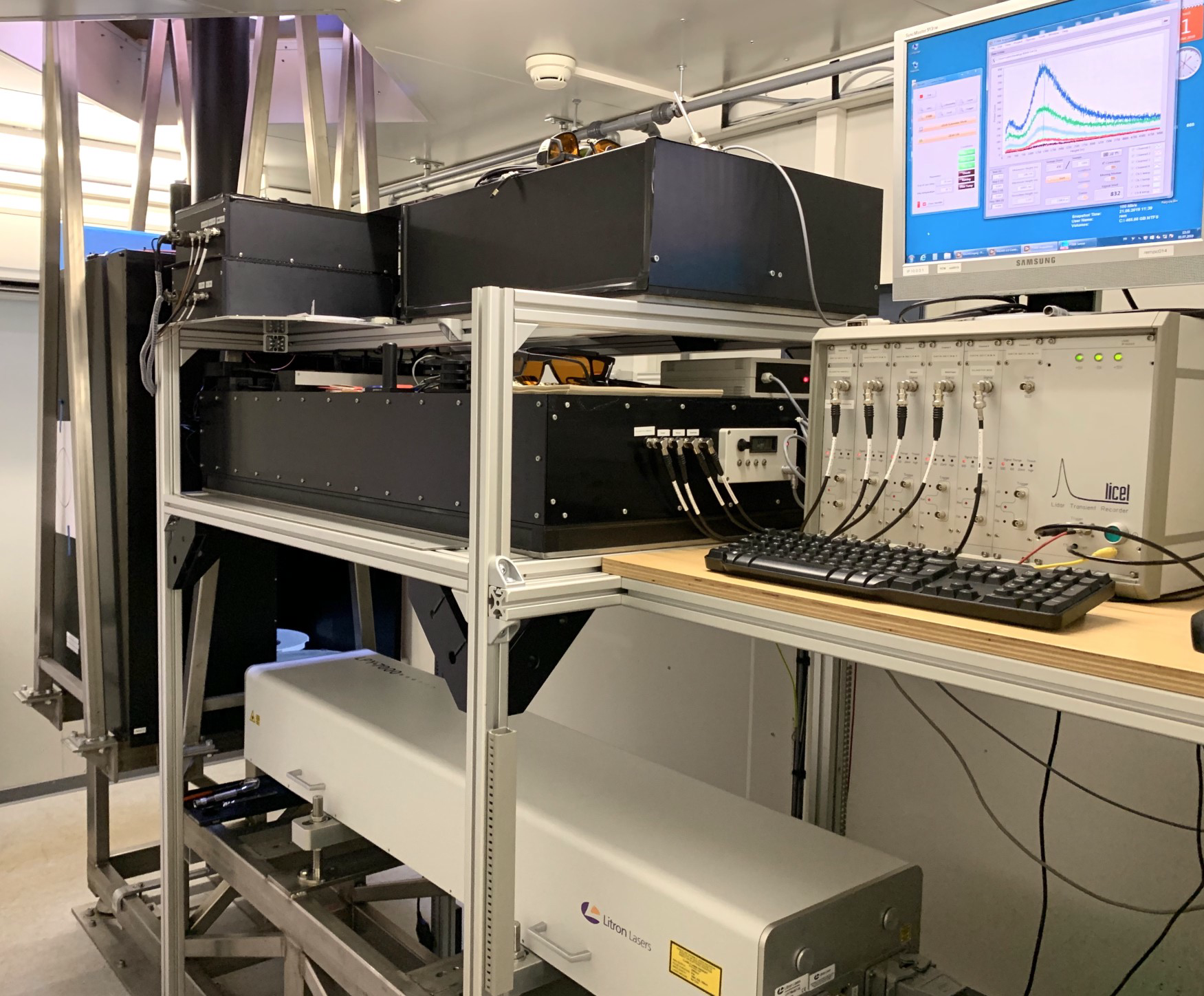
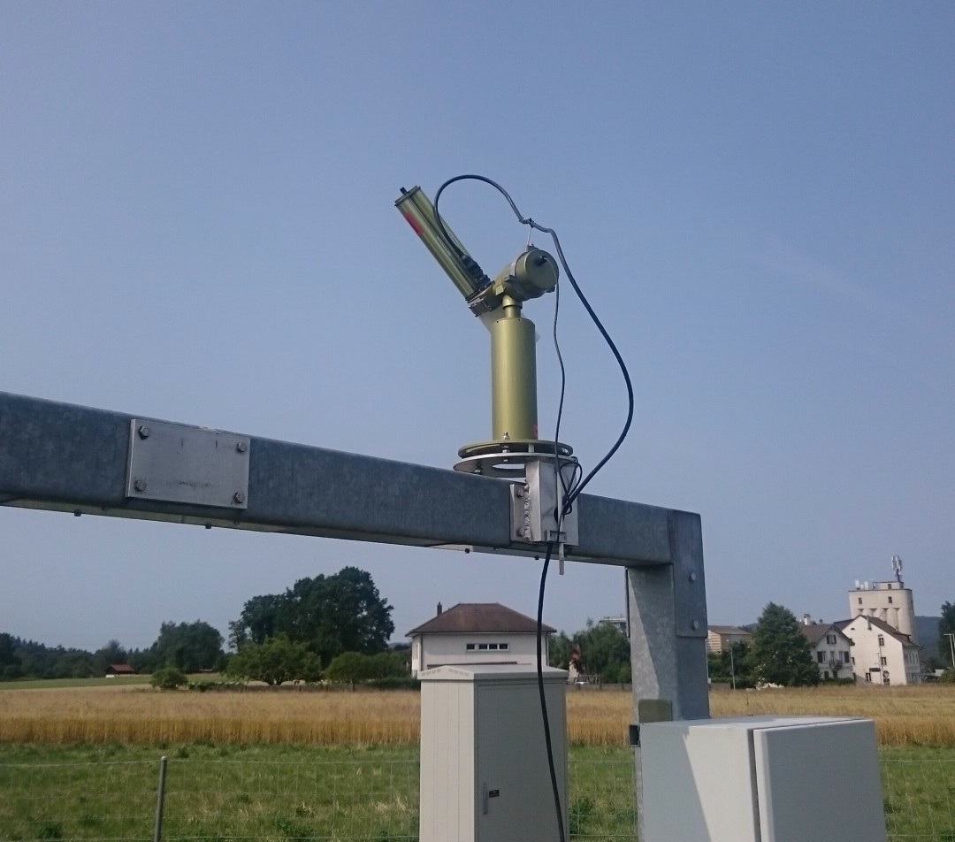
Image 1: The MeteoSwiss lidar operated in Payerne. The laser lies on the bottom stage of the frame, below the unit detecting and spectrally analysing the light backscattered by the atmosphere.
Image 2: The sun/sky photometer installed at the MeteoSwiss station in Payerne.
Cloud remote sensing in Payerne
Clouds vary rapidly in space and time, with associated fast change in the radiation and precipitation impinging on the Earth’s surface. The ACTRIS objective to provide continuous long-term vertical profiles of cloud fraction and water and ice cloud properties requires the synergistic use of several instruments. A Doppler cloud radar and a ceilometer (an automated and simplified version of a lidar) actively sense the atmosphere with high spatial and temporal resolutions, each in a different portion of the electromagnetic spectrum (mm and sub-mm wavelength, respectively), which allows for disentangling ambiguities in the detected atmospheric targets. They are complemented by a passive microwave radiometer that measures the downwelling thermal emission from the atmosphere and its components (mainly oxygen, water vapour and cloud liquid water), observations from which atmospheric thermodynamic properties can be deduced. Finally, a disdrometer measures the size and falling velocity distributions of precipitation at the surface. The ceilometer and the microwave radiometer already operate regularly in Payerne, while the disdrometer and the Doppler cloud radar will be implemented soon.
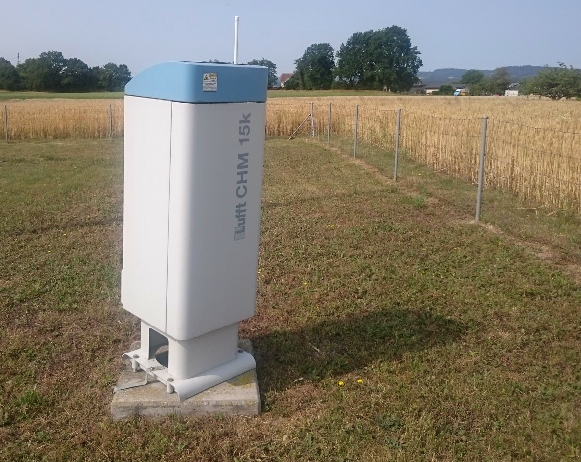
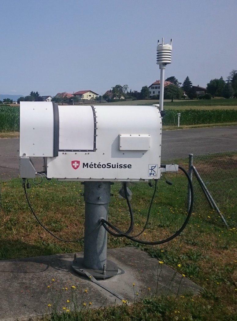
Image 1: The ceilometer at the MeteoSwiss station in Payerne.
Image 2: The microwave radiometer at the MeteoSwiss station in Payerne.
Aerosol in situ observations in Payerne
Air quality relevant aerosol parameters have been measured for many years as part of the National Air Pollution Monitoring Network (NABEL). Implementation of a more comprehensive set of continuous aerosol observations was initiated in 2019 as part of a GAW-CH Science project, which became later integrated in ACTRIS-Switzerland. Measured aerosol parameters include particle number concentrations and size distributions, aerosol scattering and absorption coefficients, equivalent black carbon mass concentrations, and aerosol chemical composition.
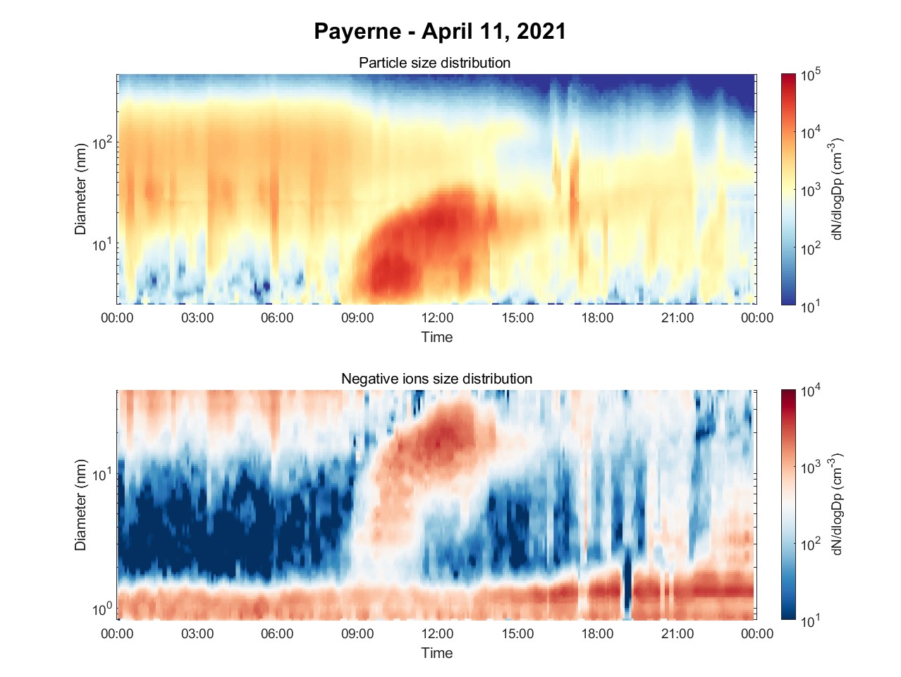
The formation of new aerosol particles in the atmosphere as measured by two different aerosol in situ instruments in Payerne. Photo: Lubna Dada
Cloud in situ observations in Payerne
Ice nucleating particles, or INPs, are special types of aerosols that aid in the formation of ice clouds. INP concentrations are continuously measured in Payerne with an instrument known as the HINC-Auto. The HINC-Auto is based on the same operational principle and design of the University of Toronto Continuous Flow Diffusion Chamber (UT-CFDC) and the Horizontal Ice Nucleation Chamber (HINC). It has been modified to enhance accuracy, portability and to be run autonomously and continuously at measurement stations.
A HINC-Auto has been in continuous operation in Payerne since May 2023. The research goal in this work is to monitor the diurnal, seasonal and annual INP concentrations at this site, which is in a location affected by bioaerosols such as pollen and their fragments, as well as fungal spores. This site also experiences some anthropogenic emissions in its vicinity. The real-time INP concentrations measured at the Swiss Midland site Payerne are shown in quasi real-time on the data sub-page. Realtime INP concentrations (Std L-1) can also be found at ETH IAC Ice Nucleation Research. If you would like to use the data, do not hesitate to get in touch with us. An example of the data on INP concentrations can be found here and usage policies and data are described here.